Catskill Fire Towers Maps provided by the Trail Conference
 These five maps show trails around popular fire towers in the Catskill Forest Preserve, located on Balsam Lake Mountain, Hunter Mountain, Overlook Mountain, Red Hill, and Tremper Mountain. These maps are provided by the New York-New Jersey Trail Conference, and are also available as free app maps on your phone using the Avenza Maps app, so be sure to download them here.
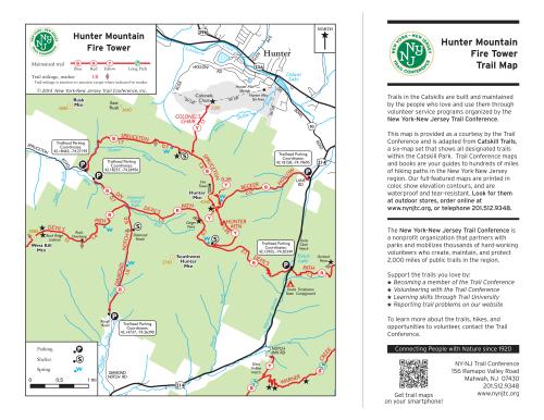
The maps are adapted from Catskill Trails, a six-map set published by the Trail Conference featuring all marked trails in Catskill Park and additional details like elevation contours. It is available in both waterproof/tear-resistant Tyvek print format as well as digital app map format for your phone.
Trails in this park are maintained by Trail Conference volunteers.
Volunteers and member organizations maintain over 200 miles of trail and 30 lean-tos in the Catskill Forest Preserve and along the Long Path north of the park boundary. Learn more about trail and lean-to maintenance, trail crew work, trainings and workshops, conservation and advocacy efforts, events, and other Catskill-related news by clicking here.
While these maps may be free to use, our organization needs your support to help protect, build, and maintain more than 2,150 miles of trails throughout the region. Support the trails you love by:
- Purchasing maps and books
- Making a donation
- Volunteering your time
- Becoming a Trail Conference member
- Telling your friends and family where to find the best trail information!
Be sure to check out our selection of other free maps!