|
|
|
Also Inside (printed version only)
-
National Trails Day
- Albany Update
- Hikers' Almanac
Catskill's Bearpen Peak Purchased by New York State
 |
At New York Governor George Pataki's press conference
announcing the State's acquisition of Bearpen Mountain for inclusion in
the Catskill Forest Preserve, Neil Woodworth (left), counsel to the
Adirondack Mountain Club and the NY-NJ Trail Conference, presented the
Governor with a copy of the New York Walk Book. Neil represented
both ADK and the Trail Conference in gaining the Governor's attention
for support of this long-sought land acquisition. Governor Pataki has
aggressively supported the campaign for open space protection during his
administration. |
In June, Bearpen Mountain in Greene County, one of the 36 Catskill High Peaks
over 3500 feet, was purchased by the State of New York to be added to the
"forever wild" lands of the Catskill Forest Preserve. The Trail
Conference and the Adirondack Mountain Club were the principal advocates for the
Bearpen purchase.
The acquisition of Bearpen Mountain has long been a priority of hiking and
outdoor recreationists. At 3,600 feet, it dominates the landscape, with steep,
rugged topography and forested slopes, and offers some of the best hiking in the
Catskills. Bearpen is the highest summit on a long ridge of
mountains that runs north-south, providing easy and good views of Hunter
Mountain, West Kill, and other Catskill High Peaks. It dominates views in the
upper Schoharie and Delaware River Valleys. The name Bearpen is likely to have
derived from the practice of hunting bear during the 1800s by constructing traps
built with stone or logs. The "bearpens" would trap the bear until the
hunter arrived. Curiously enough, though Bearpen was identified as an
"exceptional resource" in the state's Open Space Plan, it was one of
a handful that were not owned by the state.
The 1,185-acre parcel will be added to the adjacent 700-acre
Dela-ware-Greene Reforestation Area and managed by the Department of
Environmental Conservation (DEC).
Neil Woodworth, counsel to the Adirondack Mountain Club and
the New York-New Jersey Trail Conference, representing a constituency of over
135,000 hikers and campers, said, "We are delighted with the purchase of
Bearpen Mountain, a critical addition to State
lands in the Catskills. This purchase preserves this
beautiful mountain, guarantees hiking access to a popular Catskill
High Peak, and safeguards key portions of the Schoharie Creek
and Delaware River areas of the New York City Watershed. What an
incredible bargain. Kudos to Governor Pataki and Commissioner John Cahill for
this valuable purchase."
Fred LeBrun, political and outdoors columnist for the Albany
Times Union observed in his column: "We nearly lost the acquisition of
Bearpen - a dreadful thought - but Neil Woodworth, representing the 135,000
members of the Adirondack Mountain Club and the New York-New Jersey Trail
Conference, urgently warned DEC Commissioner John Cahill. A private developer
was interested, so was the City of New York, which was seeking to improve
watershed protection."
Subsequently, DEC successfully concluded its negotiations
with the owner and bought this valuable tract. ADK and the Trail Conference are
now lobbying for the purchase of a 500-acre tract on the summit of nearby Vly
Mountain.
With the acquisition of Bearpen Mountain, the State has now
protected the northwestern-most high peak in the Catskills. This wonderful new
addition to the State Forest system will provide outstanding recreational
opportunities for hikers, campers, hunters and all those who would like to enjoy
fantastic panoramic views of the Schoharie Valley and the Huntersfield Mountain
range.
The State purchased the property for $940,000, using
Environmental Protection Fund (EPF) resources. The EPF supports more than a
dozen State and local environmental programs, including the conservation of
priority open space projects identified in the State's Open Space Conservation
Plan.
Kennard Grant Bolsters Safety Training for
Trail Crews
The New York - New Jersey Trail
Conference is pleased to announce a generous gift of $8,000 from the Charles W.
Kennard Foundation. The money will allow us to establish a regular schedule of
safety refresher training for our trail crew members and leaders, and to support
general Conference operations.
This gift, together with $7,500
donated to the Trail Conference late in 1998, earmarked for several Appalachian
Trail projects, a new interpretive sign and training for our trail crew leaders,
totals $15,500 received from the Charles W. Kennard Foundation within the past
12 months.
The Trail Conference will use
part of the Kennard gift to begin a program of regular safety courses for our
volunteer trail crew members. Chainsaws, and winch/rigging systems, are accepted
tools nowadays for trail crew work of building and repairing hiking trails. As
such, workers using this equipment need to maintain a high level of skill in
operations and awareness of safety for these specialized tools.
Peter Kennard, Foundation
secretary noted, "Protecting the hiking opportunities in the immediate New
York City area is important to me. The Trail Conference, with its long history
of volunteerism and activism, is the pre-eminent organization in this region to
do that job."
While chainsaw certification
courses have been given for the past few years, re-certification courses, which
refresh an operator's skills under the eye of a certified instructor, have yet
to be presented by the Trail Conference. The hiking community standard requires
a re-certification course every three years to keep the operator current on new
techniques and standards for bucking, felling and limbing trees during trail
maintenance, as well as to maintain a strong emphasis on good safety skills.
The Trail Conference is seeking to have a member
re-certified as a chainsaw instructor, who would then be able to offer the
one-day refresher courses for our volunteers on a regular basis in-house. This
would provide greater flexibility in meeting our re-certification needs than we
currently have under a request-basis arrangement with our state and federal
agency partners.
Winch rigging systems also
demand high levels of experience and exposure to a variety of applications to
improve operators' safety. With the Kennard Foundation donation, the Trail
Conference will bring in experienced trainers on a regular schedule to transfer
their field-earned knowledge to our trail crew members.
"The Kennard Foundation
well understands the variety of skill training our volunteer trail crew members
require, and has been very supportive by earmarking portions of two generous
grants to meet those needs," said Anne Lutkenhouse, Trail Conference
Projects Director. "The Foundation's investment to provide on-going
safety skill training to our volunteers, and general operations support, assures
a legacy of trail care and improvements well into the new century."
The Trail Conference is deeply
appreciative of The Kennard Foundation's gift.
 |
from the executive director
|
|
Times and people...they are
a changin'
|
|
You will notice a new and more modern look about the Trail
Walker in this issue. We are pleased to welcome Nora Porter as
our new Designer and Managing Editor. Nora has previously designed publications
for the Trail Conference, including the New York and New Jersey Walk Books,
and has done editing and design work for a number of organizations in the Hudson
Valley. We want to thank special people who have improved our Trail Walker
and applied their well-honed skills with devotion for the past ten years,
especially Managing Editor, Alice Tufel, and Designer Tom Fenton.
The Trail Walker is only a reflection of change. The
nuts and bolts transformations are subtle, and taking place through the creation
of a Strategic Planning process for the organization.
As we enter a new millennium, it is natural to take stock.
Issues and pressures that we encounter on behalf of our 1300-mile network of
foot trails are vastly more complex than ten years ago. Our parks are in crisis
as they wither from lack of adequate funds for stewardship and management; land
development increasingly threatens our trail corridors and landscapes, and
conflicting trail uses compromise the hiking experience. A dedicated Board and
staff have devoted several retreat days, and countless hours in task force
meetings, to develop a clear mission and vision statement as guidepost, and to
establish concrete future plans for each project area within the Conference. To
best garner the necessary resources to address issues and protect our trail
lands, we must look at innovative approaches and more sophisticated support
systems. You will be hearing more about Strategic Planning in future Trail
Walkers.
All of you have received a personal invitation to attend a gala dinner dance
on September 26 to celebrate trails and honor our Trail
Conference President, H. Neil Zimmerman. Neil will step down from his office
in October after 12 years of intensely devoted service. During his tenure, his
leadership and vision have resulted in expanded hiking trail maintenance
responsibilities; new trails such as the bi-state Highlands Trail, the Long Path
North extension, and the Shawangunk Ridge Trail. Neil has forged strong
partnerships with state agencies and colleague organizations and has made land
protection a priority. He will be missed in his capacity as president, even as
we are confident of strong leadership within the organization. But, Neil has
promised to stay very involved with the Trail Conference!
And yes, at this important juncture, when we are developing a
strategic plan for the Trail Conference, it is timely for me to develop my
future plans as well. I have advised the Board of Directors that I will be
stepping down as executive director on or before December 31, 1999. After nearly
20 years of working with the Trail Conference, I will be moving on to pursue
personal goals. I have seen enormous changes within the organization over the
years, and I am proud to have had a role in its growth. It has been a constant
source of inspiration for me to work with such a passionately committed and
talented corps of volunteers and staff. The opportunities of working and
building friendships with members and colleagues has been extremely enriching.
Another gift has been my deepened connection to the land in our region-physically,
intellectually and spiritually.
I am working closely with the Board on a transition. A Search
Committee is now accepting applications and appreciates members passing along
the posting below regarding the position.
- JoAnn Dolan, Executive Director
Trail News
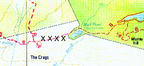
Long Path Section in Shawangunks Closed
The section of the Long Path from the western end of Mud Pond
to its junction with the High Point Trail (see the Trail Conference's
Shawangunk Trails map #9, grid C-3, shown below) has been closed by the
landowner. Please do not tresspass on this private land. When a re-route is
established, notice will be published in the Trail Walker, and noted on
our website at www.nynjtc.org.
Chainsaw Certification Course November 13 - 14
A two-day chainsaw certification course will be given by Delaware Water Gap
National Recreation Area staff for volunteers on Saturday and Sunday, November
13-14 at Camp Mohican in the National Recreation Area. This course, which is
accepted as certification for chainsaw use on National Park Service, and US
Forest Service, lands is geared for maintainers with the Appalchian Trail, or a
trail assignment within the federal lands of the Recreation Area. Training will
be both indoors and in the field, in and around Camp Mohican. To be considered
for certification through the course, participants must attend both days'
sessions. For those wishing to stay overnight, special arrangements have been
made with AMC, which operates Camp Mohican: $20 per person for space in a
full-service cabin, with use of the communal kitchen for preparing your own
food. For more details, and to register, call Anne Lutkenhouse at the Trail
Conference office, 201-512-9348.
Frank Bouton Shelter Dedication September 18
Volunteers from the Ramapo Chapter of the Adirondack Mountain
Club, in cooperation with the New York State Department of Environmental
Conservation, recently constructed a hiker's shelter on Table Mountain in the
Catskills. The site is known as the Bouton Memorial Shelter in honor of the late
Frank Bouton, an avid and active member of the hiking community. Please join us
in honoring his memory as we dedicate the shelter on Saturday, September 18. The
shelter is on the Peekamoose-Table Trail, about 3.5 miles from the Denning
Trailhead parking area-a moderately strenuous hike. Carpools will form at the
Harriman railroad station on Route 17, north of the Red Apple Rest, at 8am. Two
groups, 'A' and (more leisurely) 'B' pace, will start at Denning around
10 am for the hike in. A brief dedication ceremony is set for 1 pm. Be prepared
for a possible wet crossing of the East Branch of the Neversink, as bridges are
out. For more information call George Sheedy at 914-986-6807 or [email protected].
Rain date: Oct. 2-same times and place.
Low Impact Use Program Presented
In May, on Morris County Park Commission's Trail Day
students from St. Benedict's Preparatory School in Newark, NJ, a Trail
Conference member organization, presented a public program on low-impact use at
the Mahlon-Dickerson Reservation. St. Benedict's Prep School annually presents
a leave no trace/low impact program for youth group leaders who take their
charges onto the AT in New Jersey. This training is part of our New Jersey AT
Committee's management of group use.
Students Steve Cordova, a senior, and Terrill Harris, a
junior, and faculty member Didier Jean-Baptiste performed a skit presenting the
story of three bumbling guys who break every Leave No Trace rule imaginable
while going on an overnight backpacking trip. The program was geared towards the
younger kids in the audience, who happily pointed out the mistakes that the
"guys" made during their "trip." Steve, Terrill and Didier
pointed out what they overlooked, so everyone learned something while enjoying
themselves.
This low-impact program attracted the largest crowd of the
day, and participants took home a Leave No Trace booklet that went into more
detail and included some games to help them review the principles.
Our thanks to Steve, Terrill and Didier for their energies to present this
important public education program!
20-year effort to protect 2,100-mile Appalachian Trail nears end
The Appalachian Trail land protection program, the most
complex land acquisition program in the National Park system's history, is so
near to its conclusion - with only 26 miles not yet in public ownership -
that in this federal fiscal year 1999, Congress and President Clinton agreed to
an unusually large $15.1 million appropriation from the Land and Water
Conservation Fund, intended to acquire the final lands needed to bring the
entire AT route into public ownership by the end of 2000.
This "final appropriation" brings to an end 20
years of federal funding, which began with the 1978 amendment to the National
Trails System Act, mandating the National Park Service to put the footpath and a
corridor of lands surrounding it into public ownership.
Since the project began, annual Congressional LWCF
appropriations totaling $150 million have purchased more than 151,000 acres,
preserving 750 miles of the AT in a greenway corridor averaging 1,000 feet in
width. During this time, the AT enjoyed bipartisan political support of an
amazing longevity in the world of congressional appropriations.
The 1999 appropriations bill contains $8.1 million for the
Park Service and $7 million for the Forest Service to complete their protection
programs without having to return to Congress to request more funds. By the end
of 2000, the Park Service will protect the remaining14.4 miles of trail, and the
Forest Service, 11.5 miles.
Typically 1,000 feet wide, the AT greenway has
"preserved the entire Appalachian ridgeline from Maine to Georgia,"
and in doing so, preserved the essence of the hiking experience. It has also
given wild flora and fauna a fighting chance to survive the pressures of rampant
development. Research suggests that the greenway provides critical habitat,
supports the range's biodiversity, and may even play a role in species
migration.
Land Gifted to Appalachian Trail in Hudson Valley
The Open Space Institute and Scenic Hudson have donated a
total of 108 acres of undeveloped land in two parcels to the Appalachian Trail
for enhanced corridor and viewshed protection.
In April, through its land acquisition affiliate, the
Beaverkill Conservancy, OSI purchased a 36-acre parcel just south of South
Mountain Pass Road, which it plans to transfer to the New York State Office of
Parks, Recreation and Historic Preservation. Complementing this transaction,
earlier this year OSI and Scenic Hudson gave another Hudson Highlands parcel, a
72-acre tract known as the Stinson land, to the National Park Service.
"The Open Space Institute has been a significant partner in Appalachian
Trail land protection efforts in the Hudson Valley," commented Walt
Daniels, the Trail Conference's AT area supervisor in Putnam County.
The 36 acres, bought with a $280,000 grant from the Lila
Acheson and DeWitt Wallace Fund for the Hudson Highlands, is bordered on the
south by Camp Smith, and on the west by Hudson Highlands State Park and the AT
corridor, and contains three 800-foot peaks along a prominent ridgeline which
offer views of the Hudson River and the Hudson Highlands. The Trail Conference
will work to lay out and construct link trails through the new purchase to
existing trails in the area.
The Stinson land is a steep wooded ridgeline, first acquired
by OSI and Scenic Hudson in 1986 as part of a 300-acre assemblage, also with
funding from the Lila Acheson and DeWitt Wallace Fund for the Hudson Highlands.
OSI gave 200 of those acres to the National Park Service in 1986 to re-route a
portion of the AT through southern Putnam County, NY, where the Trail approached
the river. The remaining 72 acres-the Stinson land - was since determined as
valuable for AT corridor and viewshed protection including the Hudson River and
Bear Mountain, resulting in this year's second donation. The AT crosses the
Hudson River on the Bear Mountain Bridge, which is just west of the Stinson
Parcel.
Thank you to Open Space Institute and Scenic Hudson for its
generous Appalachian Trail land donations.
The Inca Trail to Machu Picchu: An
Andean Hiking Destination
By Anne Lutkenhouse
The Inca Trail, a path palpating with a sense of mystery deep in the Peruvian
Andes. Hiking this world-renown trail to Machu Picchu, the Lost City of the
Incas, is a very do-able, 4-day, 30-mile, classic high-wilderness adventure
route across two high passes. Each day yields lush cloud-forests and a
cornucopia of flowers and hummingbirds beneath snow-capped peaks, with visits to
more-and-more complex, well-preserved Incan sites as anticipation for reaching
Machu Picchu builds.
The trek, through the ruggedly vertical Andes, is all above
10,000 feet, with a maximum of almost 14,000 feet, and, though strenuous, with
careful pacing, is suitable for many hikers.
Combining the trek with the Winter Solstice Festival (Inti
Raymi), the greatest of all Incan celebrations, held each year in Machu Picchu's
gateway city, Cuzco, made for a wonderful hiking trip.
After the festival's introduction to Incan culture, we spent a few days
exploring nearby ruins, ranging from ceremonial baths high in the hills where
spring-fed stream waters still flow, 700 years after the Incas built them, to a
volcanic rock temple housing the three Incan "worlds" in one locale-the
under-world, explored via the subterranean rock tunnels; this-world, depicted by
the ground's surface and the rock carvings thereon; and the upper-world, the
prickly crest of volcanic rock with its altars and ceremonial channels used to
divine the future.
We set off on Day 1 from Kilometer 77, the starting point for
hiking the length of the existing Trail. The trailhead starts at the
narrow-gauge railroad tracks, passes through a tiny Quechua village, and begins
in earnest along a relatively level path through a desert-like environment
interspersed with cacti and cornfields above the Urubamba River. "Is this really
the Inca Trail?" I thought. It seemed so unremarkable, showing none of
the stonework-cribbed-trail-clinging-to-mountain-sides one associates with this
trail. As the valley began to narrow, we stopped at another Quechua community to
partake of a "Trail store," a thatched-roofed lean-to shielding some
young men and their dishtubs of river-chilled water containing bottles of
mineral water and Coca-Cola! Thus fortified, we reached the overlook to the
enormous, terrace-clad ruins of Llactapata village. Here we first felt the
hair-raising reality that we were actually walking in the footsteps of the
Incas. Continuing on under views of the snowcapped Nevado Veronica (18,865
feet, the highest peak in the Urubambas), we finished the easy day hike to set
up camp in preparation for Day 2, reputedly the most strenuous.
That night, the stars of the Southern Cross were so plump and
fuzzy, and so seemingly near, we felt we could reach up, pluck them from the
sky, and place them on our sleeping bags.
Next morning as we left the desert-like environment, the trail quite suddenly
grew steep and switch-backed, the path bare of vegetation as the valley
narrowed. Breathing became something of which I was very aware. We climbed steeply
for 5 hours or so, through plateaus hosting different ecosystems: a forest
layer, and then a cloud-forest rainforest where vegetation closed in, giving us
precious shade and cooler temperatures. The natural soil "steps"
switch-backed relentlessly over, around and through tree roots sucking the
energy from our legs, while flowering plants and birds surrounded us. Still
feeling the effects of some stomach distress, and relying on rehydration
solution for bodily fuel, this was a difficult toil for me. Yet something kept
drawing me upwards to the 13,776-foot Warmiwanusqua pass-a decisive point on
the journey. Since I was far behind the group, I could gaze upward to see humans
atop the pass silhouetted against the blue Andean sky. Seeing the goal, it now
felt within my grasp. And ever so slowly, I did reach the pass and reunion with
my fellow hikers. Having earned the view of glacier-clad peaks across the
valleys, I felt the realization to my very bones that we were deep in a primal
environment and wonderfully far from civilization.
After lunching in the lee of the pass's pinnacle, we began
a short, but steep and rocky, descent along a well-marked trail to our next camp
in a forested valley. It seemed a perverse trail routing: having achieved the
height of the pass to immediately begin descending. We would later learn this
was for Incan strategic protection purposes.
Day 3 began with a short, steep climb out of the valley
bottom, but this rise was noticeably less steep than yesterday, or is it that
our bodies have risen to the physical challenge and are now stronger?
Before cresting the second pass's 12,630 elevation, we passed a couple
of glacial tarns offering excellent views of the Pumasillo (puma's
teeth) Mountains, as well as the deep gorges and steep ridges of the eastern
Andes. Ahead of us lay the Royal Road, the 4- to 6-foot-wide, stone-paved Inca
"highway," painstakingly unearthed-the more well-known image of the
Inca Trail.
At one point, after we slithered through a narrow tunnel
carved from the rock to allow walking behind a too-steep-for-trail-building
section, our local guide, without fanfare took out his reed flute and sat down
under a special tree to play some personal melodies. As the melancholy tones
floated over me, I sat on the ancient stones to listen to the timeless sounds in
this most appropriate of places.
Approaching our campsite just shy of Phuyupatamarca (City in
the Clouds, elev. 11,975), we were jolted from our reverie by the sight-far,
far off in the distance-of the few electric lights in Aguas Caliente, the
hamlet at Machu Picchu's base, our destination at day's end tomorrow. The
Trail's remoteness, and its human history seeping into my soul through each
footstep, had so soothed my being that I cried at the thought of having to leave
it and return to civilization.
Up at 5:15 a.m. the next morning, we scamper the final
several hundred feet to view sunrise over Salcantay peak, the sun's first
light illuminating the filigree-like cut-work where snow and rock intermingle on
the snowfields of the Pumasillos. Leaving camp, we descend down 3,000 steps cut
into the mountain. The stairs, a more-recently discovered section of the
Highway, seem to drop almost straight down through the lush vegetation of the
orchid- and wild begonia-rich cloud forest. We learn the Peruvian secret to
avoid leg muscle fatigue while descending: go down sideways.
We glimpse the Winay Wayna ruins far below, whose terraces, rooms and
ceremonial baths cling to the mountainside overlooking the winding Urubamba
River. We share the path with donkeys on cargo treks led by Quechua children,
then explore the ruins, the biggest and most complex on our way. After the
precipitous de
scent, this section is quite flat, allowing plenty of time to
pause and smell the heady scents of vegetation new to us.
Although an easy, short hike from Winay Wayna to the Inti
Punku (Gate of the Sun), it takes longer than one expects since the trail
traverses many canyons, covering more distance than the eye perceives. Just when
you think you'll never reach that first view of Machu Picchu, a stone
staircase greets you around a slight bend and takes you to the Inti Punku for
the first breathtaking view of the Lost City. Your jaw drops with wonder: the
city is immense compared with other ruins we have passed, and yet, is itself
dwarfed by the enormity of the raggedly-sheer peaks towering overhead for 360
degrees.
We sat for a while trying to comprehend the image before our
eyes. The quest, the goal of our trek, lay before us, still an hour away. Yet
this point also marks the end of the wildest part of our journey, and it is this
very journey that resonates so deeply, and unexpectedly, in my core.
Hiking to Machu Picchu, if one is able, is the only way to
arrive. It gives you four days to adjust your perspective, to "tune
in" to another culture, and to share the commonality of walking experiences
with the Incas of yore.
I discovered that while the Inca Trail was initially the means to an end, it
became a life-affirming experience, a time away from our modernity, and
distilled for me the essence of what is valuable and necessary for life-shelter,
food and movement. It's about as simple as one can get, and yet it took this
journey to discover it at all.
IF YOU GO:
I went with a pre-booked tour offered by a British company,
Exodus Walking Holidays. American companies offer trips, too, all of which are
usually porter-, or horse-assisted. You can also make private arrangements in
Cuzco, spur of the moment, to hike the Inca Trail. This might be for the more
adventurous.
Hints:
-
Arrive in Cuzco (11,100 feet) at least several days ahead
of hiking to acclimatize. The altitude is a real consideration.
-
We went in winter (June - August). It was warm and sunny,
a peak time for wild flowers and plants a-bloom. Temperatures can drop to
below freezing at night in camp (we woke up to frost one morning). Rain
seldom falls during this season.
- Even at midday, clouds can obscure the sun and the apparent temperature
cools dramatically, so we layered a lot. The usual performance clothing and
gear is necessary. I recommend having some of the rehydration salts packets;
keeping hydrated at elevation is very important, and, with the change in
food, some stomach distress may result. If that happens, the salts will
insure that your body's chemistry is ready for the Inca Trail.
Hikers'  Bookshop
Nature Walks in New Jersey by Glenn Scherer. Appalachian Mountain Club Books, 1998. 219 pages. $12.95
ISBN 1878239-68-6 [Available from Trail Conference
Book Store at member prices.] 
Shawangunk: Adventure, Exploration, History and Epiphany
from a Mountain Wilderness by Marc Fried. Published by author, 1998. ISBN 0966335104
|