The purpose of this page is to provide volunteer GPSers with information about the trails that need to be GPSed for our maps.
GPS Data Collection Standards and GPS Waypoint Data Worksheets are available on the Volunteer Forms page.
Catskill Trails Map Set, 9th Edition
GPS Update - July 2009 - see below for updated 'GPS Needs' map and trail list
Work is progressing well on our new digitally-produced 9thedition of the Catskill Trails Map Set. The maps will include some significant improvements, including an expanded map coverage area, improved contour interval, NYC-DEP lands, and additional features such as trail segment mileage. We would like to include as many trails and woods roads as possible. We have received a great amount of track and waypoint data so far, so thanks to the many individuals who have contributed so far! There are still some gaps that we need filled by GPS data, so we need your help to ensure we cover as much of the Catskills as possible!
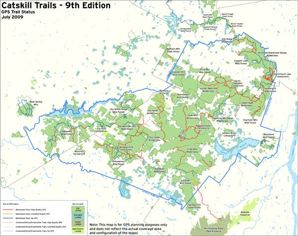
The map below shows trails that we need GPSed (indicated in orange and blue). Links for a high-resolution PDF of the map and a PDF list of the trails are available below the map for registered users of our website (if you're not registered yet, it's quick and free to Register!). This list primarily includes just blazed/named trails and not the other horse/snowmobile trails, although GPS data for these multi-use trails is also needed. If you hike with a GPS unit and would like to collect trail data in some of the indicated areas, please contact either Jeremy Apgar, cartographer, or George Dagis, project manager (see additional contact information below). In addition, if you already have track and/or waypoint data for trails in the Catskills (any and all data formats are welcome!), including any that are listed as being complete, and you would like to send it along to help with our mapping efforts, that would be greatly appreciated! If you know of anyone else that might hike with a GPS unit or have data to contribute, feel free to pass along this information.
As a final note, if you know of errors on the current edition, trail relocations, parking relocations, or anything else that you believe should be included on this new edition of the map set, please let us know!
Thank you very much in advance for your help! It is only with the help of volunteers like yourself that we are able to continue to produce high-quality hiking maps.
Note: The following map is just for GPS planning purposes and does not reflect the actual coverage area and configuration of the maps!

PDFs of map and trail list available below for registered users that are logged in:
| Attachment | Size |
|---|---|
| 1.49 MB | |
| 13.03 KB |
